‘Polar Vortex’ to Return Across the US This Week, Federal Agency Warns


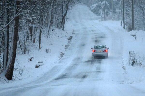
Winter storm warnings were in effect Wednesday across the western United States.

As more winter storm warnings and advisories are under effect across the western United States on Wednesday, a National Weather Service (NWS) official advised what Americans should do if they’re ever caught in a blizzard.

But starting this weekend, icy cold air from the Arctic will start to spread across the middle of the United States and will continue into the next week, said the NWS’s Weather Prediction Center in a post on Tuesday.

The agency said, “Much below normal temperatures along with gusty winds will lead to wind chills well below zero for many locations.”

According to a map posted by the weather service, when factoring in wind chill, temperatures could reach minus-60 degrees Fahrenheit in parts of North Dakota, Montana, and possibly Idaho.

Separately, it warned snow-struck regions of the Midwest and the Great Plains that temperatures could plunge dangerously low, dipping to around minus 20, and even far lower in Chicago and Kansas City.

Private forecasters including AccuWeather made similar predictions for the weekend and next week, with AccuWeather describing it as the “coldest weather so far” this season. “This outbreak of cold air will rival the arctic air mass right before Christmas 2022,” AccuWeather forecaster Tom Kines said.

The severe cold could put pressure on energy demands in the Southern United States, forecasters warned. In parts of Texas and Oklahoma, temperatures may drop to below zero Fahrenheit at night.

“The stratospheric polar vortex is now stretching down across North America,” NOAA scientist Amy Butler wrote on Tuesday afternoon. “That polar jet will be pushed further south, and guess what that does? It opens up the freezer door,” said Fox Weather Meteorologist Kendall Smith, who added: “All of that cold, arctic air that has been bottled up right over Canada, right over the Arctic, is going to be blasting its way right into the Lower 48.”

The Arctic about two weeks ago underwent a stratospheric warming, which slowed the polar vortex winds, said Ms. Butler in an article.

Temperatures for the 2024 Iowa caucuses on Monday, Jan. 22, will be close to zero degrees across much of the state, said the NWS in Des Moines. “Now is the time to check your car batteries, they will be flying off the shelves next week,” the weather service said.

Storms Persist

It came as a major storm drenched the Northeast and slammed it with fierce winds, knocking out power to hundreds of thousands following a bout of violent weather that struck most of the country. That followed a day of tornadoes and deadly accidents in the South and blizzards in the Midwest and Northwest. In some parts of the Pacific Northwest and the Rockies, more than two feet of snow fell.

The storm, which began Monday, buried cities across the Midwest in snow, stranding people on highways. Some areas saw up to a foot (30 centimeters) of snow on Monday, including Kansas, eastern Nebraska and South Dakota, western Iowa, and southwestern Minnesota. Madison, Wisconsin, was under a winter storm warning until early Wednesday, with as much as 9 inches of snow and 40 mph winds occurring.

In a bulletin on Wednesday, the NWS said that a “combination of heavy snow and strong winds will create blizzard conditions at times in parts of the Northwest through this afternoon, and storm total snow accumulations may reach several feet in the higher elevations of the Cascades and Olympics,” referring to the mountain ranges. “ Low visibility will make travel conditions particularly hazardous for many of the mountain passes.”

A car treks down a snow-covered road in Derry, N.H., on Jan. 7, 2024. (Charles Krupa/AP Photo)

Storms in the Pacific Northwest and Rocky Mountains dumped snow, including 29 inches at Stevens Pass in Washington and 30 inches outside Santa Fe, New Mexico, according to the NWS.

Authorities issued warnings for very dangerous avalanche conditions in mountainous areas of Idaho, Montana, Wyoming, Utah, Washington, and Oregon. Backcountry travelers were advised to stay off steep slopes and away from the bottom of steep slopes.

“So we were pretty lucky for a good chunk of the month of December and even into the very beginnings of January, but now it’s been a kind of page turn, if you will, a complete flip of the script,” Mr. Smith, the Fox Weather forecaster, noted. “Because now we’re starting to see that cold air that has been locked in place over Canada and over the Arctic. That’s going to be starting to change.”

Groundhog Day 2018: Other Animals That Actually Predict the Weather Better


There will either be six more weeks of winter or an early spring, depending on which groundhog you trust. The most famous groundhog, Pennsylvania’s Punxsutawney Phil, and his comrade Potomac Phil of Washington, D.C. both saw their shadows Friday morning — which, by the law of Groundhog Day means it’s going to be a long winter, baby. Meanwhile, Staten Island’s Chuck and Long Island’s Holtsville Hal didn’t see their shadows, indicating that spring-like weather is just around this miserable corner.

Groundhog Day

This “will it be winter or spring” business is largely contingent on your willingness to get the weather report from some guys in top hats judging a large rodent. That’s not scientifically advisable: Punxsutawney Phil usually doesn’t get it right, and the National Oceanic and Atmospheric Administration says that groundhogs show “no predictive skill” for weather prediction. Actual human meteorologists, meanwhile, get it right about 80 percent of the time.

Nevertheless, humans still booed Phil this morning when winter was announced because we are monsters.

But just because we can’t rely on groundhogs to give us precise weather forecasts doesn’t mean animals have zero predictive abilities. Groundhogs may unfairly get all the attention, but here are some critters who actually have a sense of what weather is to come.

Birds

birds, weather
Gold-winged warblers can predict severe weather.

It’s no secret bird flight is affected by the weather: Fierce storms can blow birds off course, and low air pressure makes it difficult for birds to fly. To survive, birds are thought to have evolved to have some predictive power when it comes to bad weather. A 2013 study from Western University’s Advanced Facility for Avian Research discovered that birds can predict weather changes by tracking the rise and fall of barometric pressure. Birds, the researchers explain, have their own internal barometers, and they typically choose not to fly when placed into conditions with high air pressure, understanding there’s a high chance they’ll encounter a storm.

In 2014, scientists discovered birds can detect severe weather in another way: They can detect the infrasound — sound waves lower than what humans can hear — of storms. In a paper published in Cell, scientists explain that golden-winged warblers, migratory birds native to North America, can pick up the low-frequency sounds, allowing them to detect storms up to 600 miles away. This ability is believed to be shared by many birds: In a 2013 study in the Journal of Experimental Biology scientists discovered that pigeons can detect infrasounds too.

Insects

moths
True armyworm moths can detect drops in atmospheric pressure.

At least some insects can predict the weather, especially when they’re trying to mate. In a paper published in PLOS One in 2013, an international team of scientists reported that curcurbit beetles, armyworm moths, and potato aphids all decided to forgo sex when the scientists lowered the atmospheric pressure in their enclosure. Female bugs stopped wafting their sex hormones toward the males, and male bugs just stopped paying attention to the females.

This disinterest in sex, the scientists believe, occurs because insects know that a drop atmospheric pressure means a rainstorm is probably coming. Rain really ruins the mood when you’re a little bug; you don’t want to be washed away while you’re out trying to do the deed. Scientists aren’t sure how the insects detect atmospheric changes but think it may come down to the hair-like receptors on their cuticle.

Sharks

sharks
Sharks sense oncoming storms.

Sharks are also sensitive to barometric pressure, which drops when a storm blows in. When they feel this drop in the ocean, they swim into deeper waters, where it’s safer. This is good news for other fish, who often note sharks’ dive to the depths as an indication that they need to swim to a safer spot as well.

When tropical storms begin to form, scientists have observed sharks migrating toward the layer of water known as the isotherm. This layer of water is 26 degrees Celsius, which is also the minimum temperature required for a storm to form. Again, scientists aren’t sure how exactly sharks know to move to this layer, but they’re currently studying shark behavior so we can steal their technology to predict hurricanes.

Not Even Bacteria Are Safe from Climate Change


Climate change has started to touch every living thing, and not even bacteria are immune from its effects.

The Earth’s warmer environment is killing off some of the world’s microbiological diversity, some of which acts as warning signals for greater environmental impacts in their ecosystems, according to a study published this week in Nature Communications. Since microbes make up the foundation of any food chain, any major impact to them might trickle down through the food chain and could impact entire ecosystems.

The study looked at bacteria and other microbes in various ecosystems, including harsh ones like high-elevation areas or frozen tundras. It found that microbes in icy environments were similar to ones in mountainous tropical regions. This suggests changes in temperature and other impacts are causing some types of microbes to die off, reducing the Earth’s microbial diversity.

“We’ve historically studied birds, mammals and plants, but we know very little about biotechnology of microbes,” said Janne Soininen, a study author from the University of Helsinki in a statement.

Figuring out how temperature changes and the increase in nutrients in water from climate change can help scientists understand how climate change will affect the very building blocks of certain ecosystems, a release announcing the study stated.

“The typically austere, i.e. nutrient-poor, waters in the north, for example, are extremely susceptible to temperature variations, and as the climate warms up, species that have adapted to the cold will decline.”

How Math Helped Forecast Hurricane Sandy.


Many early forecasts for Hurricane Sandy last year predicted that the system would fizzle over the Atlantic. Yet a model developed by researchers at the European Center for Medium-Range Forecasts showed a more alarming scenario: the storm would instead turn west to threaten the Eastern Seaboard. The model’s refined predictions pinpointed the hurricane’s landfall around the New Jersey area in time to allow residents to seek higher ground. The key to the more accurate forecast involved mathematical mastery of the storm’s chaotic behavior.

Weather forecasts are calculated with computers that solve equations involving variables such as wind speed, pressure, temperature, air density and humidity. If the earth somehow possessed just one weather system, our fist shaking at forecasts could end. Instead, of course, the planet harbors many systems that intermix across boundaries and scales, making forecasting a tangled problem.

In the case of Sandy, forecasters monitored a higher-order variable called potential vorticity, a measure of a weather system’s swirl, to help predict the storm’s future development. A crucial ingredient for Sandy’s devastating landfall proved to be an enhancement of this swirl measure caused by a trough of low-pressure air that was thousands of miles away in the northeastern Pacific when the tropical depressionfirst formed. As Sandy moved north from the Caribbean, the distant trough traveled east across the U.S. on what turned out to be a collision course. On October 29 Sandy’s warm, moist air began to rise as it approached the trough’s cooler air, whipping up stronger winds. As the two weather systems coiled around each other, Sandy surged in strength and curved toward the nation’s northeastern shoreline, just as the European researchers had foreseen. The ultimate accuracy of the group’s forecasts about a week before Sandy’s landfall can be attributed to the success of its model in predicting and capturing the interaction between these weather systems.

The step-by-step quantification of this stormy choreography was accomplished solely through the careful application of mathematics. By predicting Sandy’s landfall, in a very real sense, the European team’s math helped to save American lives.

Source: http://www.scientificamerican.com