It’s not just keeping you from getting lost.
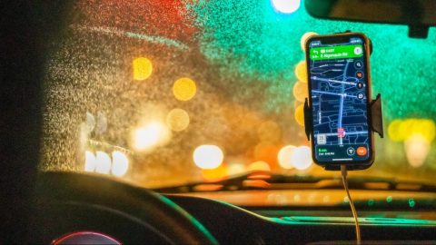
You might think you’re an expert at navigating through city traffic, smartphone at your side. You might even hike with a GPS device to find your way through the backcountry. But you’d probably still be surprised at all the things that GPS — the global positioning system that underlies all of modern navigation — can do.
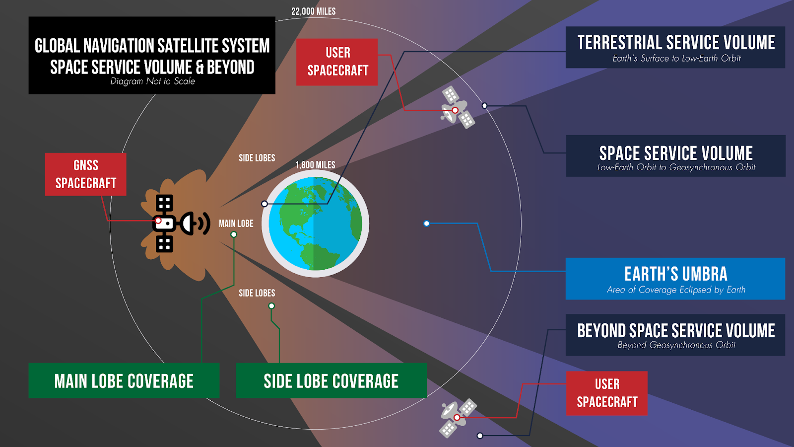
GPS consists of a constellation of satellites that send signals to Earth’s surface. A basic GPS receiver, like the one in your smartphone, determines where you are — to within about 1 to 10 meters — by measuring the arrival time of signals from four or more satellites. With fancier (and more expensive) GPS receivers, scientists can pinpoint their locations down to centimeters or even millimeters. Using that fine-grained information, along with new ways to analyze the signals, researchers are discovering that GPS can tell them far more about the planetthan they originally thought it could.
Over the last decade, faster and more accurate GPS devices have allowed scientists to illuminate how the ground moves during big earthquakes. GPS has led to better warning systems for natural disasters such as flash floods and volcanic eruptions. And researchers have even MacGyvered some GPS receivers into acting as snow sensors, tide gauges and other unexpected tools for measuring Earth.
“People thought I was crazy when I started talking about these applications,” says Kristine Larson, a geophysicist at the University of Colorado Boulder who has led many of the discoveries and wrote about them in the 2019 Annual Review of Earth and Planetary Sciences. “Well, it turned out we were able to do it.”
Here are some surprising things scientists have only recently realized they could do with GPS.
1. Feel an earthquake
For centuries geoscientists have relied on seismometers, which measure how much the ground is shaking, to assess how big and how bad an earthquake is. GPS receivers served a different purpose — to track geologic processes that happen on much slower scales, such as the rate at which Earth’s great crustal plates grind past one another in the process known as plate tectonics. So GPS might tell scientists the speed at which the opposite sides of the San Andreas Fault are creeping past each other, while seismometers measure the ground shaking when that California fault ruptures in a quake.
Most researchers thought that GPS simply couldn’t measure locations precisely enough, and quickly enough, to be useful in assessing earthquakes. But it turns out that scientists can squeeze extra information out of the signals that GPS satellites transmit to Earth.
Those signals arrive in two components. One is the unique series of ones and zeros, known as the code, that each GPS satellite transmits. The second is a shorter-wavelength “carrier” signal that transmits the code from the satellite. Because the carrier signal has a shorter wavelength — a mere 20 centimeters — compared with the longer wavelength of the code, which can be tens or hundreds of meters, the carrier signal offers a high-resolution way to pinpoint a spot on Earth’s surface. Scientists, surveyors, the military and others often need a very precise GPS location, and all it takes is a more complicated GPS receiver.
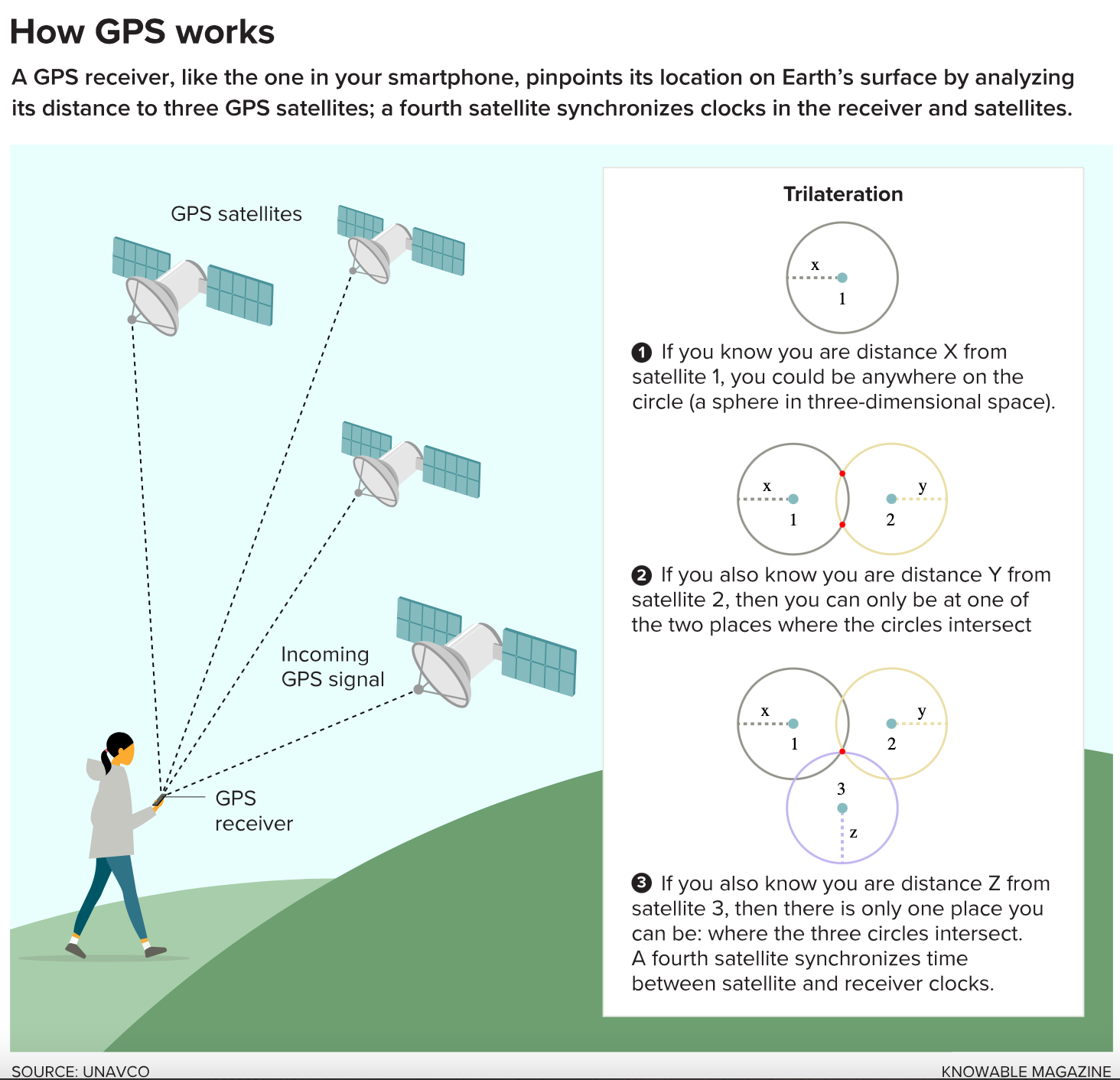
Engineers have also improved the rate at which GPS receivers update their location, meaning they can refresh themselves as often as 20 times a second or more. Once researchers realized they could take precise measurements so quickly, they started using GPS to examine how the ground moved during an earthquake.
In 2003, in one of the first studies of its kind, Larson and her colleagues used GPS receivers studded across the western United States to study how the ground shifted as seismic waves rippled from a magnitude 7.9 earthquake in Alaska. By 2011, researchers were able to take GPS data on the magnitude 9.1 earthquake that devastated Japan and show that the seafloor had shifted a staggering 60 metersduring the quake.
Today, scientists are looking more broadly at how GPS data can help them quickly assess earthquakes. Diego Melgar of the University of Oregon in Eugene and Gavin Hayes of the US Geological Survey in Golden, Colorado, retrospectively studied 12 large earthquakes to see if they could tell, within seconds of the quake beginning, just how large it would get. By including information from GPS stations near the quakes’ epicenters, the scientists could determine within 10 seconds whether the quake would be a damaging magnitude 7 or a completely destructive magnitude 9.
Researchers along the US West Coast have even been incorporating GPS into their fledgling earthquake early warning system, which detects ground shaking and notifies people in distant cities whether shaking is likely to hit them soon. And Chile has been building out its GPS network in order to have more accurate information more quickly, which can help calculate whether a quake near the coast is likely to generate a tsunami or not.
2. Monitor a volcano
Beyond earthquakes, the speed of GPS is helping officials respond more quickly to other natural disasters as they unfold.
Many volcano observatories, for example, have GPS receivers arrayed around the mountains they monitor, because when magma begins shifting underground that often causes the surface to shift as well. By monitoring how GPS stations around a volcano rise or sink over time, researchers can get a better idea about where molten rock is flowing.
Before last year’s big eruption of the Kilauea volcano in Hawaii, researchers used GPS to understand which parts of the volcano were shifting most rapidly. Officials used that information to help decide which areas to evacuate residents from.
GPS data can also be useful even after a volcano has erupted. Because the signals travel from satellites to the ground, they have to pass through whatever material the volcano is ejecting into the air. In 2013, several research groups studied GPS data from an eruption of the Redoubt volcano in Alaska four years earlier and found that the signals became distorted soon after the eruption began.
By studying the distortions, the scientists could estimate how much ash had spewed out and how fast it was traveling. In an ensuing paper, Larson called it “a new way to detect volcanic plumes.”
She and her colleagues have been working on ways to do this with smartphone-variety GPS receivers rather than expensive scientific receivers. That could enable volcanologists to set up a relatively inexpensive GPS network and monitor ash plumes as they rise. Volcanic plumes are a big problem for airplanes, which have to fly around the ash rather than risk the particles’ clogging up their jet engines.
3. Probe the snow
Some of the most unexpected uses of GPS come from the messiest parts of its signal — the parts that bounce off the ground.
A typical GPS receiver, like the one in your smartphone, mostly picks up signals that are coming directly from GPS satellites overhead. But it also picks up signals that have bounced on the ground you’re walking on and reflected up to your smartphone.
For many years scientists had thought these reflected signals were nothing but noise, a sort of echo that muddied the data and made it hard to figure out what was going on. But about 15 years ago Larson and others began wondering if they could take advantage of the echoes in scientific GPS receivers. She started looking at the frequencies of the signals that reflected off the ground and how those combined with the signals that had arrived directly at the receiver. From that she could deduce qualities of the surface that the echoes had bounced off. “We just reverse-engineered those echoes,” says Larson.
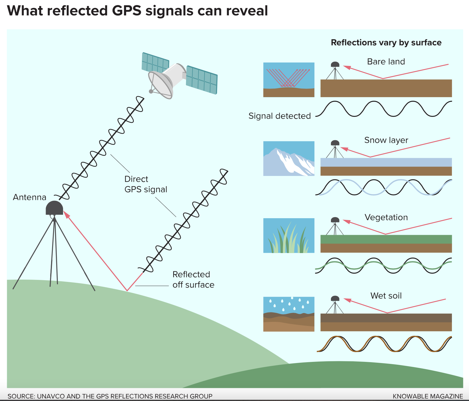
This approach allows scientists to learn about the ground beneath the GPS receiver — for instance how much moisture the soil contains or how much snow has accumulated on the surface. (The more snow falls on the ground, the shorter the distance between the echo and the receiver.) GPS stations can work as snow sensors to measure snow depth, such as in mountain areas where snowpack is a major water resource each year.
The technique also works well in the Arctic and Antarctica, where there are few weather stations monitoring snowfall year-round. Matt Siegfried, now at the Colorado School of Mines in Golden, and his colleagues studied snow accumulation at 23 GPS stations in West Antarctica from 2007 to 2017. They found they could directly measure the changing snow. That’s crucial information for researchers looking to assess how much snow the Antarctic ice sheet builds up each winter — and how that compares with what melts away each summer.
4. Sense a sinking
GPS may have started off as a way to measure location on solid ground, but it turns out to be also useful in monitoring changes in water levels.
In July, John Galetzka, an engineer at the UNAVCO geophysics research organization in Boulder, Colorado, found himself installing GPS stations in Bangladesh, at the junction of the Ganges and Brahmaputra rivers. The goal was to measure whether the river sediments are compacting and the land is slowly sinking — making it more vulnerable to flooding during tropical cyclones and sea level rise. “GPS is an amazing tool to help answer this question and more,” Galetzka says.

Subscribe for counterintuitive, surprising, and impactful stories delivered to your inbox every Thursday
Fields marked with an * are required
In a farming community called Sonatala, on the edge of a mangrove forest, Galetzka and his colleagues placed one GPS station on the concrete roof of a primary school. They set up a second station nearby, atop a rod hammered into a rice paddy. If the ground really is sinking, then the second GPS station will look as if it is slowly emerging from the ground. And by measuring the GPS echoes beneath the stations, the scientists can measure factors such as how much water is standing in the rice paddy during the rainy season.
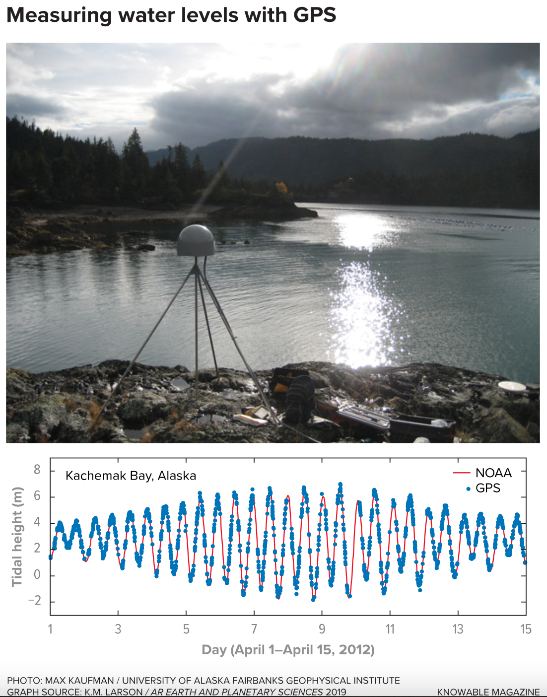
GPS receivers can even help oceanographers and mariners, by acting as tide gauges. Larson stumbled onto this while working with GPS data from Kachemak Bay, Alaska. The station was established to study tectonic deformation, but Larson was curious because the bay also has some of the biggest tidal variations in the United States. She looked at the GPS signals that were bouncing off the water and up to the receiver, and was able to track tidal changes almost as accurately as a real tide gauge in a nearby harbor.
This could be helpful in parts of the world that don’t have long-term tide gauges set up — but do happen to have a GPS station nearby.
5. Analyze the atmosphere
Finally, GPS can tease out information about the sky overhead, in ways that scientists hadn’t thought possible until just a few years ago. Water vapor, electrically charged particles, and other factors can delay GPS signals traveling through the atmosphere, and that allows researchers to make new discoveries.
One group of scientists uses GPS to study the amount of water vapor in the atmosphere that is available to precipitate out as rain or snow. Researchers have used these changes to calculate how much water is likely to fall from the sky in drenching downpours, allowing forecasters to fine-tune their predictions of flash floods in places like Southern California. During a July 2013 storm, meteorologists used GPS data to track monsoonal moisture moving onshore there, which turned out to be crucial information for issuing a warning 17 minutes before flash floods hit.
GPS signals are also affected when they travel through the electrically charged part of the upper atmosphere, known as the ionosphere. Scientists have used GPS data to track changes in the ionosphere as tsunamis race across the ocean below. (The force of the tsunami produces changes in the atmosphere that ripple all the way up to the ionosphere.) This technique could one day complement the traditional method of tsunami warning, which uses buoys dotted across the ocean to measure the height of the traveling wave.
And scientists have even been able to study the effects of a total solar eclipse using GPS. In August 2017, they used GPS stations across the United States to measure how the number of electrons in the upper atmosphere dropped as the moon’s shadow moved across the continent, dimming the light that otherwise created electrons.
So GPS is useful for everything from ground shaking beneath your feet to snow falling from the sky. Not bad for something that was just supposed to help you find your way across town.