Scientists have discovered the elusive properties hidden within promethium, a rare earth element that has remained largely unexplored since its discovery 80 years ago.
This landmark research, published in the journal Nature, marks a significant advance in rare earth studies and has the potential to rewrite chemistry textbooks.
Promethium’s 80-year scientific journey
The story of promethium began in 1945 at the Oak Ridge National Laboratory (ORNL), formerly known as Clinton Laboratories. It was here that the element was first discovered and continues to be produced in minute quantities.
Named after the mythological Titan who delivered fire to humans, promethium symbolizes the human quest for knowledge and understanding.
Alex Ivanov, an ORNL scientist who co-led the research, expressed the team’s sense of obligation to uphold the laboratory’s legacy.
“The whole idea was to explore this very rare element to gain new knowledge. Once we realized it was discovered at this national lab and the place where we work, we felt an obligation to conduct this research to uphold the ORNL legacy,” Ivanov explained.
Unlocking the mysteries of promethium
The research team, led by ORNL scientists, prepared a chemical complex of promethium, enabling its characterization in solution for the first time.
Through a series of meticulous experiments, they exposed the secrets of this extremely rare lanthanide, whose atomic number is 61.
Ilja Popovs, another co-lead of the research from ORNL, highlighted the challenges faced in studying promethium, saying, “Because it has no stable isotopes, promethium was the last lanthanide to be discovered and has been the most difficult to study.”
Rare earth elements, particularly lanthanides (elements 57-71 on the periodic table), are crucial components in many modern technologies, from lasers and permanent magnets to X-ray screens and cancer-fighting medicines.
However, the lack of understanding surrounding promethium has been a significant gap in scientific knowledge.
Santa Jansone-Popova, also a co-lead of the study from ORNL, emphasized the importance of this research.
“There are thousands of publications on lanthanides’ chemistry without promethium. That was a glaring gap for all of science. Scientists have to assume most of its properties. Now we can actually measure some of them,” Jansone-Popova enthused.
Collaborative effort across national labs
The success of this research relied on the unique resources and expertise available at DOE national laboratories.
The team utilized a research reactor, hot cells, and supercomputers, as well as the accumulated knowledge and skills of 18 scientists from various fields.
To study promethium’s properties, the ORNL scientists bound radioactive promethium-147 with special organic molecules called diglycolamide ligands.
Using X-ray spectroscopy, they determined the length of the promethium chemical bond with neighboring atoms, a first for science and a long-missing piece of the periodic table puzzle.
Promethium is incredibly rare; only about a pound occurs naturally in the Earth’s crust at any given time. Unlike other rare earth elements, only minute quantities of synthetic promethium are available due to its lack of stable isotopes. ORNL is the sole producer of promethium-147 in the United States.
Understanding Lanthanide Contraction
One of the most significant findings of this study was the first demonstration of lanthanide contraction in solution for the entire lanthanide series, including promethium.
Lanthanide contraction refers to the phenomenon where elements with atomic numbers between 57 and 71 are smaller than expected, with their ionic radii decreasing as atomic numbers increase.
“It’s really astonishing from a scientific viewpoint. I was struck once we had all the data. The contraction of this chemical bond accelerates along this atomic series, but after promethium, it considerably slows down,” Ivanov noted.
This is an important landmark in understanding the chemical bonding properties of these elements and their structural changes along the periodic table.
Implications for modern technology
The discovery of promethium’s properties has far-reaching implications for modern technology.
Many rare earth elements, including those in the lanthanide and actinide series, have applications ranging from cancer diagnostics and treatment to renewable energy technologies and long-lived nuclear batteries for deep space exploration.
Jansone-Popova highlighted the importance of this achievement in the separation of these valuable elements.
“You cannot utilize all these lanthanides as a mixture in modern advanced technologies, because first you need to separate them,” Jansone-Popova explained.
“This is where the contraction becomes very important; it basically allows us to separate them, which is still quite a difficult task.”
Promethium ushers in a new rare earth era
The team’s achievement sets the stage for a new era of research in rare earth elements.
“Anything that we would call a modern marvel of technology would include, in one shape or another, these rare earth elements. We are adding the missing link,” Popovs concluded.
In summary, this important research on promethium opens a new frontier in the exploration of rare earth elements.
By unlocking the secrets of this elusive element, the team has filled a significant gap in scientific knowledge and paved the way for future discoveries.
The implications of this study extend far beyond the realm of basic science, as promethium and other rare earth elements play a crucial role in modern technologies, from medical applications to renewable energy and space exploration.
As scientists continue to build upon this landmark achievement, we can expect to see a new era of innovation and advancement in the fields of chemistry, materials science, and beyond.
A new study suggests more solar radiation reached Earth while the magnetic field weakened, leading to a rise in oxygen that drove an explosion of multicellular organisms during the Ediacaran Perio
An illustration of some of the underwater creatures that lived during the Ediacaran Period, roughly 635 million to 541 million years ago.
Earth’s magnetic field sustains life on our planet, protecting us from solar winds, radiation and extreme changes in temperature. But around 591 million years ago, it almost collapsed. According to a new study, this near-disaster may have actually been the key to a burst of evolution, which paved the way for larger and more varied life forms to develop.
Published in the journal Communications Earth & Environment this month, the study found that a drastic weakening of Earth’s magnetic field that lasted for 26 million years corresponded with a period of the planet’s history called the Ediacaran. During this time, a large amount of oxygen in Earth’s atmosphere and oceans allowed for the first multicellular, oxygen-using organisms to arise from the sea.
The creatures that evolved during the Edicaran hardly resembled anything seen today, however, taking on disc-like forms and shapeless masses—some of which exceeded three feet in size. These fronds and fans include Earth’s earliest known animals, such as the blob-like Dickinsonia.
Scientists theorize that without the protection of the magnetic field roughly 600 million years ago, solar radiation pounded the Earth’s atmosphere, stripping away hydrogen and other light gases from the atmosphere. This left behind an abundance of free-floating oxygen atoms for organisms to use.
“If we’re right, this is a pretty profound event in evolution,” lead author John Tarduno, a geophysicist at the University of Rochester, tells Stephanie Pappas of Live Science.
A fossil impression of Dickinsonia, one of the earliest known animals, found in present-day Australia.
Building on previous research that pointed to historical fluctuations in the magnetic field, the team of researchers examined rocks containing crystals that cooled over tens or hundreds of thousands of years. Now, these structures act as time capsules, evidencing the strength of the magnetic field at various points in Earth’s development.
An analysis of feldspar from southern Brazil revealed that 591 million years ago, the magnetic field was 30 times weaker than it is now. But two-billion-year-old rock from South Africa suggested that at that time, the magnetic field held the same strength it does today.
Then, Earth’s core was liquid, not solid. The liquid inner core churned as it released heat into the cooler mantle, moving molten iron around the core and enabling Earth’s magnetic field to exist. By the Ediacaran, this difference in temperature had decreased, reducing the movement of the core and, consequently, the presence of the magnetic field.
“By the time we get to the Ediacaran, the field is on its last legs,” Tarduno explains to CNN’s Katie Hunt. “It’s almost collapsing. But then, fortunately for us, it got cool enough that the inner core started to generate [strengthening the magnetic field].”
The new findings also shed light on a long-standing question: At what point did the Earth’s core solidify? Previous estimates ranged from 2.5 billion to 500 million years ago, but the team’s analysis places the event on the more recent end of that spectrum, closer to 565 million years ago. The solidification of the inner core was also a crucial event for the evolution of life—it allowed Earth’s magnetic field to regain its strength and protect the planet’s water from being entirely eroded by solar radiation.
“We need the Earth’s magnetic field to preserve water on the planet,” Tarduno tells Live Science. “But it is sort of an interesting twist that during the Ediacaran, the really weak magnetic field may have helped accelerate evolution.”
Previously, the scientific consensus held that photosynthesizing organisms like cyanobacteria created the surplus of oxygen during the Ediacaran, and it accumulated in the oceans over time, study co-author Shuhai Xiao, a geobiologist at Virginia Tech, writes to CNN.
The new findings don’t necessarily disprove this idea—instead, they might show the Earth gained oxygen in multiple ways.
“We do not challenge that one or more of these processes was happening concurrently. But the weak field may have allowed oxygenation to cross a threshold, aiding animal radiation [evolution],” Tarduno says to CNN.
David Dunlop, a physicist at the University of Toronto who was not involved in the research, tells Dino Grandoni of the Washington Post that while the recent work needs further study, the analyses were “impeccably done.”
“The hypothesis, although obviously speculative as any ideas about the earliest origins of life must be, seems worth a close look,” Dunlop tells the publication. “Causality is always hard to prove, but I am all for new ideas being put out for public scrutiny. It provokes further study and that is all to the good.”
OUR PLANET IS TURNING INTO A ROCKY PLANET LIKE MERCURY OR MARS MUCH “FASTER THAN EXPECTED.”
According to new research, the core of the Earth is cooling much faster and sooner than originally anticipated — a new mystery that could throw a wrench in our understanding of the planet’s evolution.
To get a better sense of how far along the Earth is in the process, scientists are studying the thermal conductivity of the minerals present in the layer between the planet’s core and mantle. The faster that hot center passes heat to the planet’s outer layers, the faster the Earth is losing the heat present in its core.
Heating Rocks
In a lab simulation, a team of researchers from ETH Zurich in Switzerland and the Carnegie Institution for Science applied immense amounts of pressure and heat to a mineral called bridgmanite — which is found in the transitional zone between the core and mantle — to simulate the conditions deep below the surface. They then measured its thermal conductivity to get a better sense of the cooling processes at play.
The results were surprising.
“This measurement system let us show that the thermal conductivity of bridgmanite is about 1.5 times higher than assumed,” said ETH professor Motohiko Murakami, lead author of a paper about the findings published in the journal Earth and Planetary Science Letters, in a statement.
In other words, the heat from the core is being passed on at a much faster rate than previously thought, leading to the greater cooling of the Earth.
A New Perspective
The study could rewrite what we already know about the dynamic processes leading to the slowing down of convection currents.
“Our results could give us a new perspective on the evolution of the Earth’s dynamics,” Murakami explained. “They suggest that Earth, like the other rocky planets Mercury and Mars, is cooling and becoming inactive much faster than expected.”
The researcher did, however, note we didn’t know enough to pinpoint how long it will take for convection currents to stop altogether.
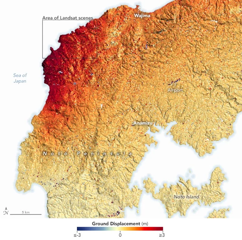
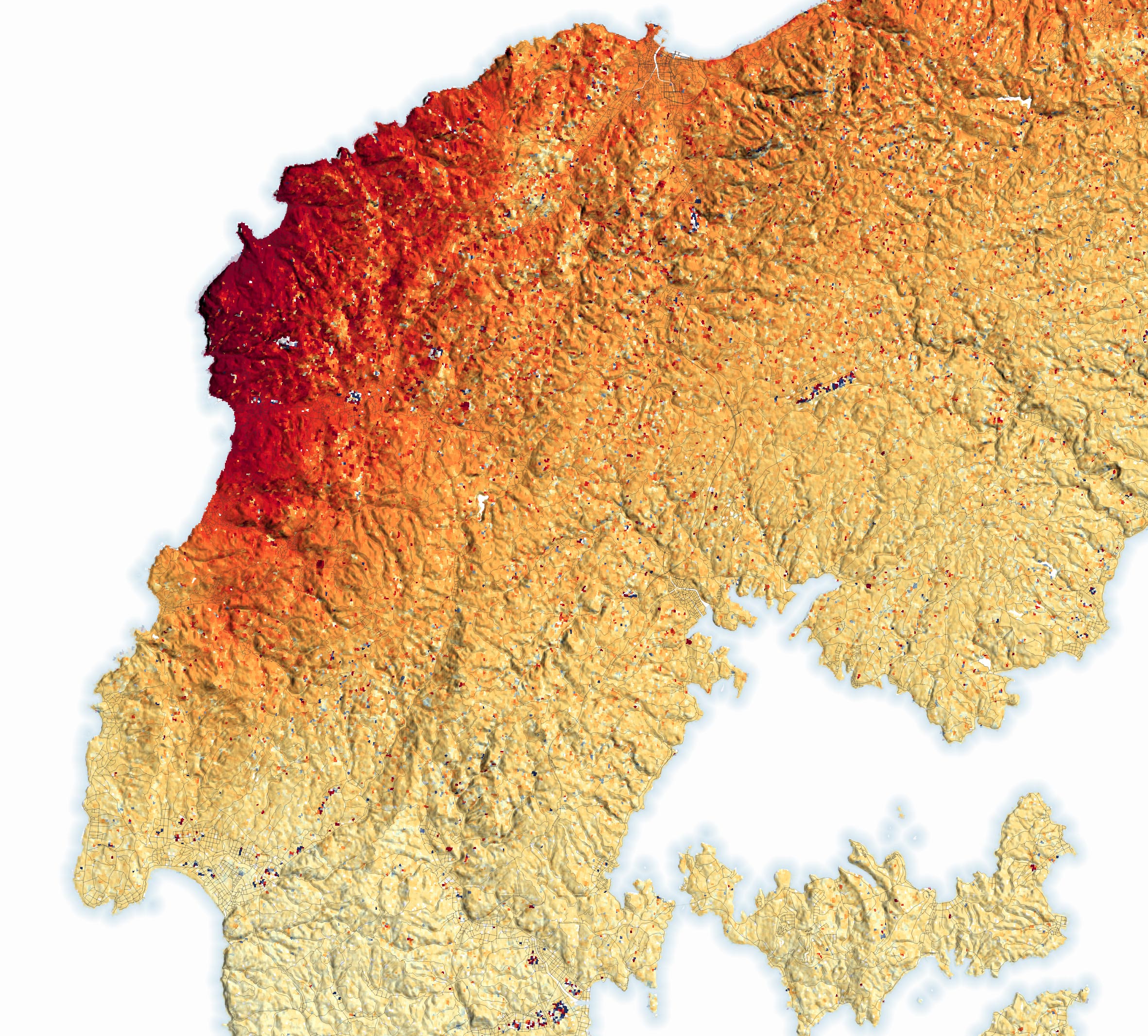
Ground displacement on the Noto Peninsula in northwestern Honshu, Japan caused by the Earthquake on January 1, 2024.
Some parts of the peninsula rose up to 4 meters (13 feet), shifting the position of coastlines and leaving some ports dry.
The first day of 2024 brought catastrophe to parts of Japan. At 4:10 p.m. Japan Standard Time (07:10 Universal Time), the land on the Noto Peninsula in northwestern Honshu began to lurch, shaking violently for about 50 seconds. The 7.5 magnitude mainshock was followed by dozens of strong aftershocks in the following minutes, hours, and days.
The earthquake on January 1, 2024, was the strongest to hit Ishikawa Prefecture since 1885 and mainland Japan since the 2011 Tohoku earthquake. Shaking was felt across much of Honshu including Tokyo, located about 300 kilometers southeast of the earthquake’s epicenter. Shaking was most intense in the towns of Suzu, Noto, Wajima, and Anamizu, close to the epicenter on the northern Noto Peninsula.
Damage to infrastructure ignited fires that burned through communities. Heavy snow that fell after the quake complicated emergency response efforts, making it difficult for aid to reach some communities.
Scientific Analysis of the Earthquake
As first responders reacted to the disaster from the ground, several teams of scientists tracked the situation using satellites. The map above shows the amount of ground displacement—the shifting of the land—caused by the earthquake. Red areas were pushed upward and toward the northwest. The scattered dark blue and red areas around the airport and other cleared areas and settlements throughout the peninsula are likely false signals caused by how the shapes of buildings or other features reflect radar signals.
“The surface moved upward as much as 4 meters (13 feet) on some parts of the north coast of the Noto Peninsula,” said Eric Fielding, a geophysicist at NASA’s Jet Propulsion Laboratory (JPL). “The uplift is large because the fault ruptured close to the surface—at a depth of about 10 kilometers (6 miles). It occurred on a fault with a steep dip angle, and the south side of the fault moved upward—what we call a thrust earthquake.”
Earthquakes occur at a variety of depths. Those that occur between 0 to 70 kilometers are shallow, between 70 and 300 kilometers are intermediate, and between 300 and 700 kilometers are deep. Earthquakes that occur at shallow depths, like this one, tend to be more destructive because the seismic waves generated have less time to lose energy as they travel from the source of a quake to the surface.
Advanced Satellite Data and Coastal Changes
The map is based on data from the Advanced Rapid Imaging and Analysis (ARIA) team at JPL and the California Institute of Technology’s Seismological Laboratory, a team that develops state-of-the-art deformation measurements, change detection methods, and physical models for use in hazards science and response. The ARIA team used synthetic aperture radar data from the PALSAR-2 sensor on the Japan Aerospace Exploration Agency’s ALOS-2 (Advanced Land Observing Satellite-2) and a pixel offset tracking technique to measure surface displacement in the line-of-sight between the ground and the satellite.
Additional analysis of ALOS-2 observations by scientists from the Geospatial Information Authority of Japan indicates that the earthquake uplifted land along 85 kilometers (52 miles) of coastline. It shifted the location of the coastline roughly 200 meters seaward at Minazuki Bay, one of the areas that saw the most uplift. They also reported a large amount of uplift and new land in Waijma and Nafune.
Goto Hideaki, a geomorphologist from Hiroshima University, with colleagues from the Association for Japanese Geographers, used aerial photographs and satellite data to estimate that the quake exposed a total of 4.4 square kilometers of land along the coasts of the Nota Peninsula.
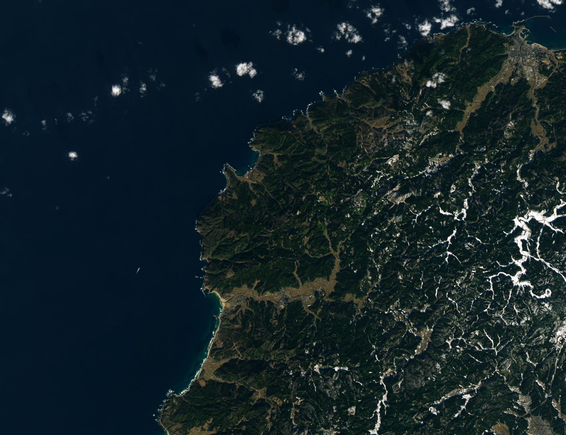
Satellite image of the coastline around Minazuki Bay, Japan captured by the Operational Land Imager-2 on Landsat 9 on January 10, 2022.
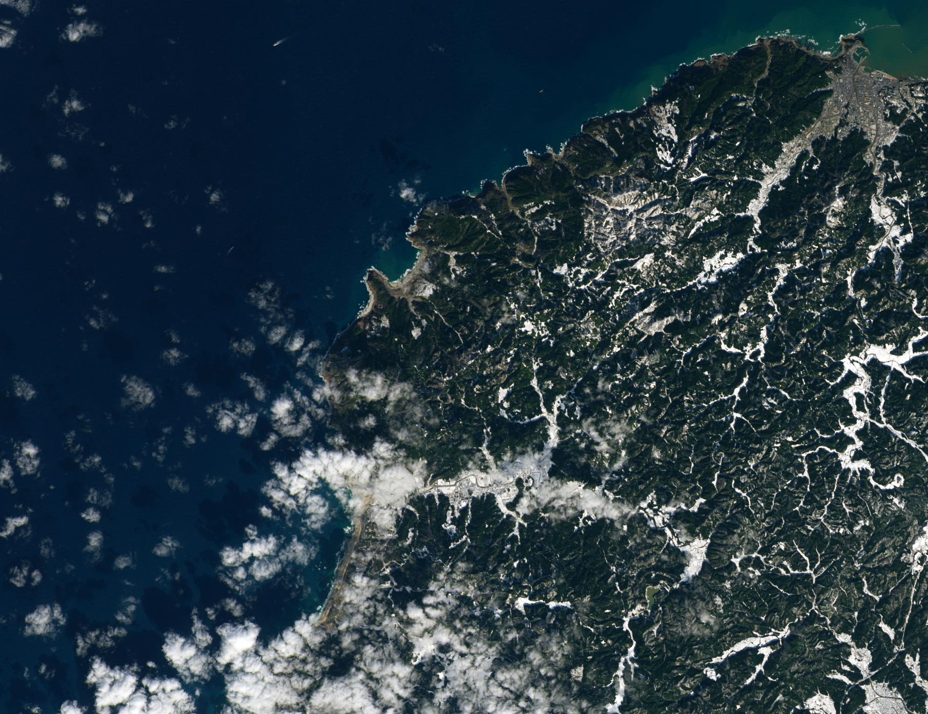
Satellite image of the coastline around Minazuki Bay, Japan captured by the Operational Land Imager on Landsat 8 on January 17, 2024.
Some of the coastline changes around Minazuki Bay are visible in the pair of Landsat images above. The upper image, from the OLI-2 (Operational Land Imager-2) on Landsat 9 was acquired on January 10, 2022, before the earthquake. The lower image, from the OLI (Operational Land Imager) on Landsat 8 was acquired on January 17, 2024, after the event. The bay hosts two small fishing ports that were left much higher and drier than usual. More than 15 fishing ports in Ishikawa Prefecture reported uplift, according to The Asashi Shimbun.
Satellite data often proves useful for emergency aid organizations assisting with disaster response immediately after an event because it can be used to rapidly locate the most severely damaged areas. Over longer time spans, satellite data can also help authorities make more informed decisions about recovery and rebuilding as they prepare for the possibility of future events.
Turns out there was a lot of burying and melting going on at the beginning of the world.
Gear-obsessed editors choose every product we review. We may earn commission if you buy from a link. Why Trust Us?
Scientists know that the world’s continents emerged during the Archean eon, which stretched from about 4 to 2.5 billion years ago. But how they formed is a tougher question.
A new study from the University of British Columbia reveals that magmatism of Earth’s current crust’s precursor formed three rocks—tonalite, trondhjemite and granodiorite, known collectively as TTGs—that likely formed the first continents.
This idea would rule out that meteorites or subduction zones were required to form TTGs and, subsequently, continents.
The formation of the Earth’s continents occurred during a fiery afterbirth known as the Archean Eon, which stretched from 4 billion to 2.5 billion years ago. It was in this bubbling cauldron of magmatic activity that geologic forces created the world’s first continents. While geologists have narrowed down the “when” of continental formation, the “how” is still a pretty big mystery.
That’s because the origin story of Earth’s continents is a bit of a chicken-or-egg question: Did the first continents form as the result of primordial subduction zones, or did existing ancient land masses produce the first subduction zones? In a new paper published last week in the journal Nature Communications, scientists from the University of British Columbia tipped the scales in the direction of the latter.
Three types of granitoid rocks are central to this geologic origin story—tonalite, trondhjemite, and granodiorite—which together are known as TTG. Evidence of Archean TTG rock can be found throughout the world, and even in your home, as varieties of this type of rock can be found in kitchen countertops. But exactly where did this early continental rock come from?
“We tracked a specific set of trace elements that aren’t affected by alteration and pristinely preserve signatures from the original magma that made new TTG crust,” lead author Matthijs Smit, an associate professor the University of British Columbia’s Department of Earth, Ocean and Atmospheric Sciences, said in a press statement. “These elements allowed us to look back through the chemical changes that TTG magmas go through and trace the melt compositions back to their initial state and source.”
Smit’s team discovered that TTG rocks (and other rocks associated with them) formed from a “slow burial, thickening, and melting of precursor crust.” This ancient proto-crust likely resembled the oceanic plateaus of today, and because this crust kept being buried, the base had no choice but to melt. And voilà: TTGs were created, which then formed the Earth’s first continents.
According to the scientists, the discovery of this standalone “intra-crustal” formation disproves the idea that TTGs could’ve formed from the geologic crust-making factories known today as subduction zones. So if subduction zones are the chicken and TTG magmatism is the egg, it turns out the egg came first (which also happens to be true of chickens).
“We show that these things may actually not be directly related,” Smit said. “The recognition of the type of source rock makes this leap possible and also takes away the need to have other mechanisms, such as meteorite impact, to explain the growth of the first real continents.”
New regulations for drilling into the seabed could come any day now, following two years of infighting between an international regulatory body, drilling companies, and scientists.
The deep ocean is a mysterious, pitch-black world populated by creatures specially adapted to the crushing pressure, the dark, and the near-freezing temperatures. Though the ocean covers 70 percent of Earth’s surface, less than one percent of the deep ocean—about 200 meters deep, where light begins to dwindle—has been mapped. Frequently, when scientists explore there, they discover species we never even knew existed. But they also have discovered that this ecosystem is full of metals like manganese, nickel, cobalt, and lithium that humans use in everything from phones and electric cars to wind turbines.
Private companies and a number of countries are eager to mine these metals, though the process is generally very destructive to ecosystems. After scientists simply raked the seabed in a 1972 experiment to test the environmental impacts, the area they tested never recovered.
Yet, companies may soon get the green light to conduct deep-sea mining anyway.
The Fox in the Henhouse
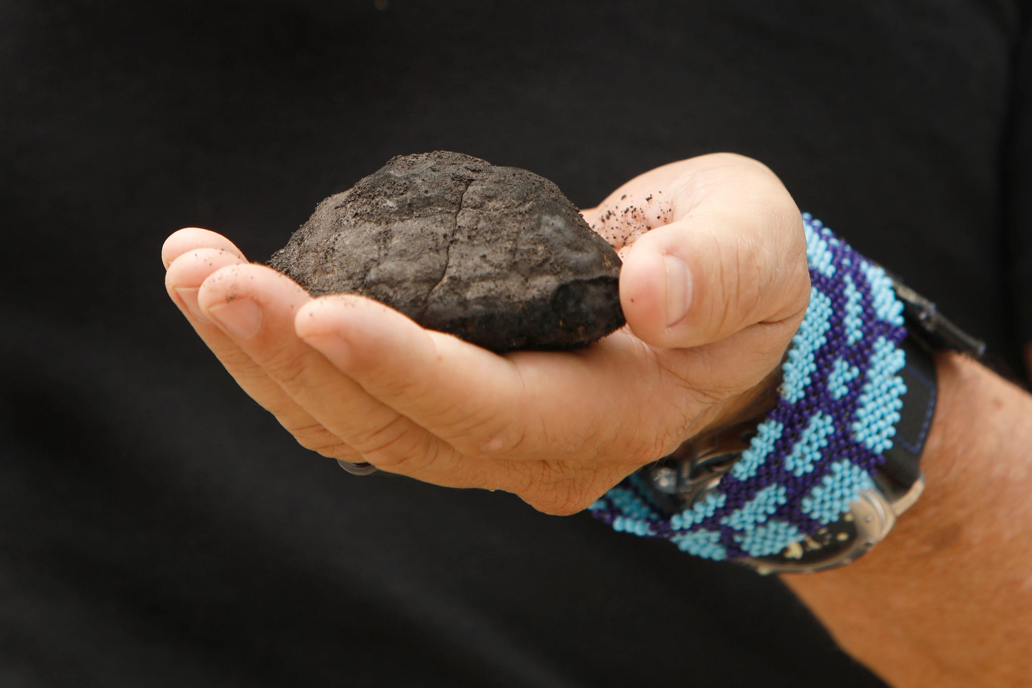
Gerard Barron, chairman and CEO of The Metals Company, holds a nodule brought up from the seafloor, which he plans for his company to mine in the Clarion Clipperton Zone of the Pacific Ocean, June 2021.
The Kingston, Jamaica-based International Seabed Authority (ISA), an autonomous organization under the auspices of the United Nations, is in charge of that decision. Created in 1994, the ISA is charged with protecting the marine environment in international waters “for all mankind.” It governs about 54 percent of the ocean—the ocean that is essential to planetary health, because it generates 50 percent of the oxygen we use, absorbs 25 percent of carbon dioxide emissions, and captures 90 percent of excess heat humans create. The ISA is also in charge of issuing contracts to extract resources from international waters, and creating regulations for such extraction, which many conservationists liken to putting the fox in charge of the henhouse. It’s further charged with guarding the rights of developing nations, so that if resources are extracted, wealthy nations do not unfairly benefit from what is considered a common human heritage.
Some have accused Michael Lodge, the secretary general in charge of the ISA, of being overzealous when it comes to mining. A 2022 New York Times investigation included documents showing that since 2007, the ISA has been sharing key information with a Canadian mining company, now known as The Metals Company; it also set aside the most promising tracts for that company, including the mineral-rich Clarion-Clipperton Zone (CCZ) in the Pacific. This prompted some agency employees to quit in protest. While the ISA’s role was to protect developing nations, The Metals Company, which anticipates garnering $85 billion from the area, plans to pay only 10 percent to the developing countries sponsoring it
That New York Times investigation was not the only article about Lodge’s apparent advocacy for mining. There have been others in publications including The Los Angeles Times and The Guardian. And a recent New York Times story reports that diplomats from ISA member nations called Lodge out for clashing with council members who wanted to slow the implementation of mining.
The ISA is governed by a 36-member rotating council that represents 169 member states, including 167 countries and the European Union. Some of these members say Lodge has stepped outside his administrative role in pushing for deep-sea mining. Popular Mechanics was unable to reach Lodge for comment.
Gerard Barron, chairman and CEO of The Metals Company, hopes that his company will be able to mine the seafloor for nickel, cobalt, and manganese in the Pacific Ocean.
Some council members—including Russia, China, South Korea, India, Britain, Poland, and Brazil—have applied and been approved for contracts to explore deep-sea mining; the ISA does not yet have authority to issue contracts to exploit the resources. (Brazil, for its part, just called for a ten-year moratorium on deep-sea mining.) But several other countries—including France, Germany, Spain, New Zealand, and Costa Rica—want a moratorium on deep-sea mining until its impacts are better understood. They are joined by the United Nations Environment Program, the World Bank, and nearly 800 scientists. Meanwhile, several companies, including Google, Volvo, and Samsung, have signed a pledge not to use materials extracted from the deep sea until it is “clearly demonstrated that such activities can be managed in a way that ensures the effective protection of the marine environment.”
Thanks to a rule written into the United Nations Convention on the Law of the Sea (UNCLOS), a set of regulations for deep-sea mining may be forced into place before the science is clear. This rule states that if a government expresses an interest in mining in international waters, the ISA has 24 months to create a regulatory framework for that activity. In 2021, one of The Metals Company’s sponsors, plus a member of the ISA’s council, the Pacific nation of Nauru, triggered that rule. July marks 24 months.
The Deep Sea: Mining Resource or Crucial Ecosystem?
These black polymetallic sea nodules—nickel, manganese, and cobalt-rich mineral deposits—are balls that form naturally deep under the sea.
Proponents of deep-sea mining, such as mining companies and countries interested in cashing in on rare-earth and other minerals, contend that the transition to renewables is absolutely dependent on these minerals. Rare-earth metals are used in electric car batteries, cell phones, and wind farms, and are considered essential in transitioning from fossil-fuel vehicles to electric ones. Failing to mine these metals, they say, will lead to shortages and slow the renewable transition.
They argue that tons of these metals can simply be sucked up from the abyssal plains, like the CCZ, where they now lie in the form of polymetallic nodules, which look like loose rocks resting on the bottom of the ocean. According to the United States Geological Survey, a conservative estimate of polymetallic nodules in the Clarion-Clipperton Zone manganese nodule field, the largest globally, is 21.1 billion dry tons—that is more than the known tonnage of many critical metals in reserves on land.
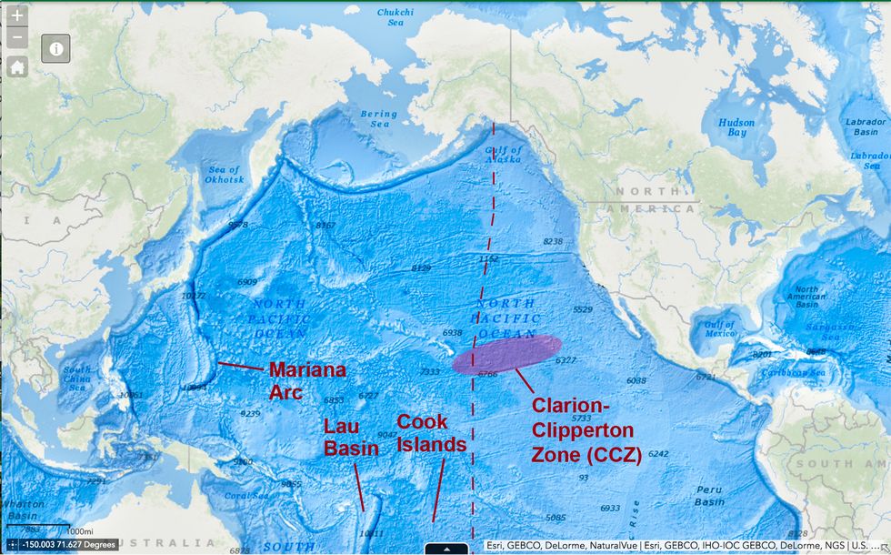
Pacific Ocean, showing locations of Clarion-Clipperton Zone (CCZ), the Mariana Arc, Lau Basin, and the Cook Islands.
Other metals that are expected to be mined are in cobalt-rich ferromanganese crusts and near thermal vents. About 7.5 billion dry tons of cobalt-rich ferromanganese crusts are estimated in the Pacific Ocean Prime Crust Zone. Theoretically, this could stem some of the human rights abuses commonly associated with cobalt mining.
Gerrard Barron, CEO of The Metals Company, suggests that deep-sea mining will allow terrestrial mining to diminish.
“There needs to be an acceptance of the fact that we need more metals,” he tells Reuters. “Why does it make sense to destroy rainforests to mine nickel, but not extract the metal from the bottom of the ocean at a part of the planet with the least life on it?”
In a single expedition to the Clarion-Clipperton Zone in May 2023, more than 5,000 new species were discovered.
Catherine Weller, director of global policy for Fauna & Flora International, tells Popular Mechanics that Barron’s argument is fallacious. (The organization, founded in 1903, lists Sir David Attenborough as a vice president.) It published a widely circulated report in 2020 about the environmental damage of deep-sea mining. There’s no reason to believe that terrestrial mining will stop or even slow just because deep-sea mining commences, Weller says. And as for no life being where the mining is intended to occur, Fauna & Flora’s marine director, Sophie Benbow, says that’s far from true; the deep sea is thriving with biodiversity. In a single expedition to the Clarion-Clipperton Zone in May 2023, more than 5,000 new species were discovered, and most of them were endemic to the region and not found anywhere else on the planet.
The metallic nodules on the abyssal plains that miners want to hoover up form over millions of years in a remote part of the planet where fine sediment filters down at a rate of about a centimeter every millennium. It is home to untold thousands of species.
A Psychropotes longicauda sea cucumber is seen as it is transferred into an ethanol-filled specimen jar for scientific preservation, in a laboratory within the Natural History Museum on May 24, 2023 in London, England. Collected from the seabed using a remotely-operated system, researchers have managed to collect thousands of samples of deep-sea anthropods, many of which are being seen for the first time. A new study has highlighted the extent of biodiversity in the Clarion-Clipperton Zone, the world’s largest mineral exploration region. The research has found that over 90 percent of species in one of the most likely future mining sites are currently undescribed by science, and are threatened by deep-sea mining, due to a global surge in demand for metals such as cobalt and nickel.
The ferromanganese crusts host corals, sponges, tuna, sharks, dolphins, and sea turtles. Hydrothermal vents, where ore is also found, are superheated liquid rising to the water column from closer to Earth’s core. They give us clues to the origins of life and harbor their own unique and rare ecosystem that functions largely without photosynthesis.
“Mining in those areas, we would wipe out huge numbers of species,” Benbow says, many of which are “quite funky.” “They’re so uniquely adapted to living in near freezing temperatures, almost complete darkness, massive pressures. And there are some pretty cool creatures.” She lists the Dumbo octopus, species of snailfish with holes in their skulls to deal with the pressure, and the sea pangolin. “The species in the deep, they are unique and beautiful in their own right … each of them have their own role in that ecosystem.
Studying these species, their adaptation strategies, and their ecosystem could also lead to discoveries in areas such as medicine and technology, Weller argues. Conversely, mining in the area is widely believed to mean the complete and irreversible destruction of the ecosystem with far-reaching consequences. Disturbing an ecosystem that has been protected on the seafloor for millennia, Benbow notes, could also exacerbate climate change.
“At the bottom of the sea, there are sediments [that] have been found to be one of the most expansive and critical carbon reservoirs on the planet,” she says. Deep-sea mining would disrupt those sediments, even if a company were just “vacuuming” nodules off the seafloor. Plus, any impacts in the ocean would enter the water column and possibly damage very large areas up to kilometers away.
Is Deep-Sea Mining Worth It?
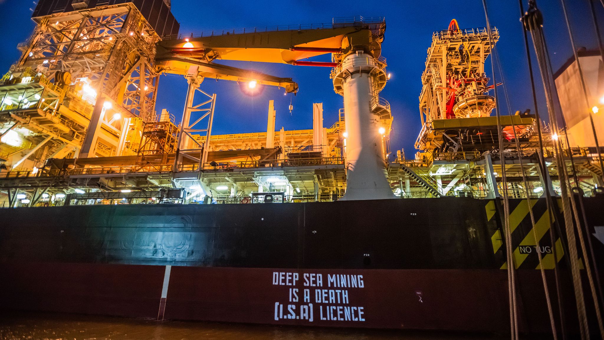
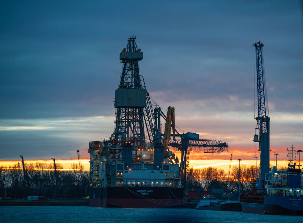
The sun sets on the mining vessel Hidden Gem after a demonstration against deep-sea mining, February 8, 2022, the Netherlands.
There is also a question about whether deep-sea mining would, in fact, solve the problems it promises to solve. An article in Nautilus quoted investor and deep-sea explorer Victor Vescovo as noting that the deep sea is an extremely hostile environment to those not designed to live there, and certainly to machinery. Between the incredible pressure of the deep sea, the salt water, the cold, and the darkness, machinery operating there must be incredibly resilient. He argues that the investment needed to mine this inhospitable area would not justify the cost.
Moreover, the permanent batteries constructed from such minerals—while hailed as a solution to the CO2 problem—have created their own problem. One study showed that, between 2010 and 2020, the use of permanent magnets cumulatively resulted in 32 billion tons CO2-equivalent of greenhouse gas emissions globally. (This is a calculation comparing it with greenhouse gas emissions.)
And Fauna & Flora’s Weller notes that emerging technologies may soon make rare-earth mining unnecessary. Experiments are underway to replace the rare-earth metals we currently use with materials that can be created in a lab. And more and more countries are turning to recycling rare-earth materials. Plus, some of the assumptions that are intended to justify deep-sea mining, such as the argument that the renewable transition requires replacing all fossil fueled cars with electric ones, negates other, possibly better solutions. This includes increasing public transit and reducing the number of cars on the road, since most of them spend 90 percent of their time parked, anyway.
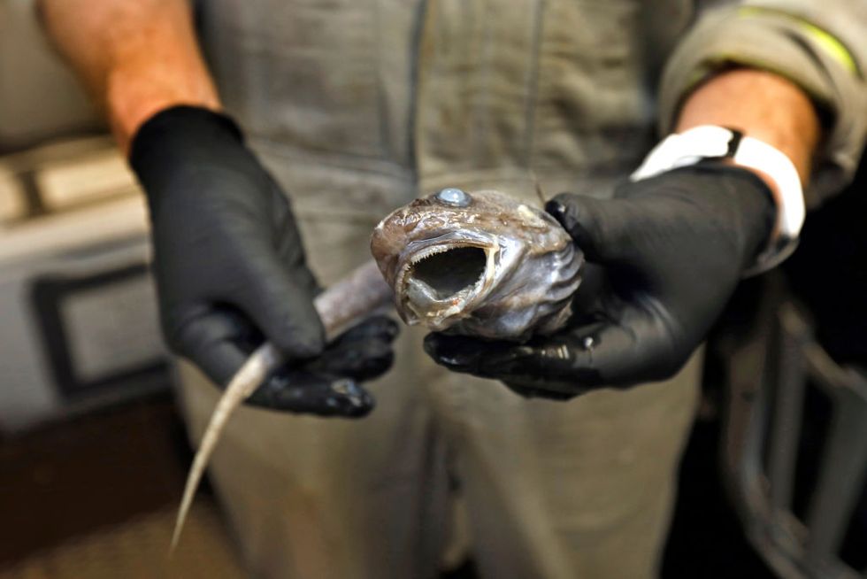
Andrew K. Sweetman, professor and research leader at the Lyell Centre for Earth, Marine Science, and Technology at Heriot-Watt University in Edinburgh, Scotland, holds a deep-water fish, called a Rattail, brought up as part of the research to see the effects mining will have on the environment in the Clarion Clipperton Zone of the Pacific Ocean, June 2021.
Though the ISA was scheduled to start taking applications for deep-sea mining in July, many of its council members believe such decisions are premature. Conservationists hope the ISA will find a different solution to help the renewable transition.
“I think it would be pretty ridiculous,” Weller says, “to be in the process of solving one crisis by creating another huge crisis.”
Gear-obsessed editors choose every product we review. We may earn commission if you buy from a link. Why Trust Us?
Every 8.5 years or so, the Earth emits a signal—the result of a “wobble” occurring in the inner core.
To explain this phenomenon, scientists from Wuhan University analyzed polar movement and length-of-day changes, and concluded that the inner core is 0.17 degrees off of the rotational axis of the mantle.
Although this idea goes against the conventional theory of the core-mantle relationship, it could help explain other geomagnetic phenomena.
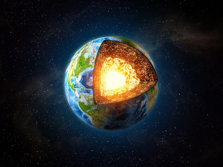
Few things are more vital to our existence—yet less understood—than the Earth’s inner core. Surrounded by a cocoon of liquid metal (aka the outer core), this solid mass of nickel and iron at the planet’s heart is what creates the Earth’s magnetic field, which protects all life from harmful solar radiation. Despite this essential, life-sustaining function, the inner core remains a huge mystery for geologists eager to understand the deep workings of the world.
For example, scientists had noticed that the inner core tends to wobble, but had no clue why. Now, scientists at Wuhan University hope to at least check this one seismic oddity off the mystery list. Their study, published this month in the journal Nature Communications, argues that this “Inner Core Wobble” (ICW) occurs every 8.5 years and implies that the static tilt of the core is 0.17 degrees different from the rotation axis of the mantle. The team came to this conclusion by studying polar motion (PM) and length-of-day changes (ΔLOD).
“This implies a potential eastward differential rotation angle of the inner core of less than 1 degree and misalignment in the symmetry axes of the lower mantle/core-mantle boundary layer with the upper mantle,” Wuhan University research and study co-author Hao Ding said in an interview with Phys.org. “These deviations offer valuable constraints for the 3D density model of the mantle and question assumptions in the liquidity-core oblate, highlighting potential deviations from a perfectly spherical form calculated using traditional theories.”
In another study from 2018, Ding first discovered evidence of the 8.5-year harmonious signal while studying the subtle movement of Earth’s poles over time. The core’s tilt, as compared to the mantle, goes against the typical hypothesis that the tilt of those two layers are in sync. Ding also thinks that the origin of this “signal” could explain why the Earth’s magnetic field changes over time.
“The static tilt may also lead to a certain change in the shape of the liquid core, resulting in a change in the fluid motion and a corresponding change in the geomagnetic field,” Ding said in the interview.
While this theory explains some of the mysterious oddities surrounding the Earth’s inner core, it’s only one theory among several. As Vice notes, one idea points the finger instead at the push-and-pull forces between the Earth’s magnetic field and its gravitational field. Another focuses on the irregular shape of the core itself.
And while humans can’t simply travel to the center of the Earth (despite what sci-fi may tell you) geologists will continue analyzing the subtle hints—whether earthquake rumbles or harmonic wobbles—to figure out the amazing, life-sustaining machinations at the heart of the planet we call home.
Seismic waves travel differently through innermost core than through outer section.
Seismic waves have helped researchers to learn about the layers that comprise Earth’s solid centre.
The reverberations from earthquakes as they bounce back and forth through the centre of Earth have revealed new details about the structure of the planet’s inner core, according to a study published in Nature Communications this week1.
For several decades, evidence has been mounting to suggest that the planet’s solid inner core is made up of distinct layers2,3 but their properties have remained mysterious.
To better understand the inner core’s structure, researchers used multiple seismometers to examine how seismic waves are distorted as they pass through the solid ball of iron nickel at Earth’s heart. “Earth oscillates like a bell after a large earthquake, and not just for hours, but days,” says co-author Hrvoje Tkalčić, a geophysicist at the Australian National University in Canberra, Australia.
To detect these oscillations, researchers recorded the waveforms at close to the original site of the earthquake and at the antipode —the direct opposite position on the surface of Earth. This enabled them to look at the multiple journeys through Earth’s centre. “It’s like a ping-pong ball that’s bouncing back and forth,” says co-author Thanh-Son Pham, a postdoctoral fellow at the Australian National University. Each reverberation takes around twenty minutes to cross from one side of the planet to the other, and the seismometers recorded up to five bounces from a single event.
Stacked measurements
The original earthquakes each reached a magnitude of greater than six, but the waves got progressively weaker as they passed through Earth’s core. The researchers used a technique called ‘stacking’, in which they combined the waveforms from a single event to build a more detailed picture of the distortion from the innermost core.
They found that the waves travelled differently through the innermost inner core — which they estimate to be around 650 kilometres thick — than through the outer part. Waves passing through the innermost part of the core slowed down in one direction, whereas waves passing through the outer layer slowed down in another direction. “It simply means that the iron crystals — iron, which is dominant in the inner core — is probably organized in a different way than in the outer shell of the inner core,” Tkalčić says.
Geophysicist Vernon Cormier at the University of Connecticut in Storrs says that the study is important because it offers a measurement of Earth’s innermost section that was very difficult to achieve. “It requires finding seismic waves recorded at very long distance and that are fairly weak in amplitude, and then enhancing the amplitude so that you could measure the wave speed in the very deep interior of the Earth,” says Cormier.
Although the technique is routinely used for minerals exploration, it is not commonly used in geophysics.
The latest finding will help in understanding how Earth’s solid inner core formed — a process that is thought to have started somewhere between 600 million and 1.5 billion years ago — and what role that might have had in shaping the magnetic field.
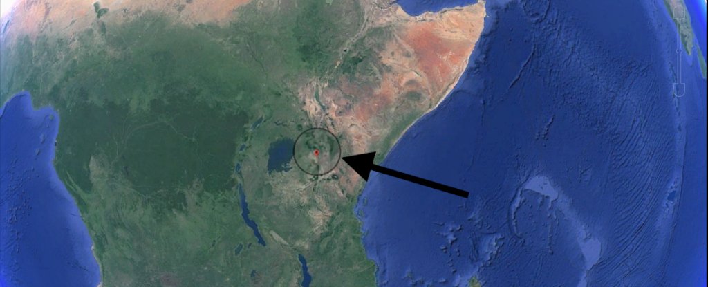
A huge crack has appeared in Kenya, and it’s growing.
A large crack, stretching several kilometres, made a sudden appearance recently in south-western Kenya.
The tear, which continues to grow, caused part of the Nairobi-Narok highway to collapse and was accompanied by seismic activity in the area.
The Earth is an ever-changing planet, even though in some respects change might be almost unnoticeable to us. Plate tectonics is a good example of this.
But every now and again something dramatic happens and leads to renewed questions about the African continent splitting in two.
The Earth’s lithosphere (formed by the crust and the upper part of the mantle) is broken up into a number of tectonic plates.
These plates are not static, but move relative to each other at varying speeds, “gliding” over a viscous asthenosphere.
Exactly what mechanism or mechanisms are behind their movement is still debated, but are likely to include convection currents within the asthenosphere and the forces generated at the boundaries between plates.
These forces do not simply move the plates around, they can also cause plates to rupture, forming a rift and potentially leading to the creation of new plate boundaries.
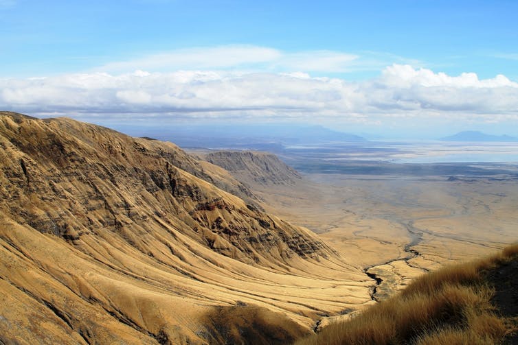
The East African Rift Valley stretches over 3,000 km from the Gulf of Aden in the north towards Zimbabwe in the south, splitting the African plate into two unequal parts: the Somali and Nubian plates.
Activity along the eastern branch of the rift valley, running along Ethiopia, Kenya and Tanzania, became evident when the large crack suddenly appeared in south-western Kenya.
Why does rifting happen?
When the lithosphere is subject to a horizontal extensional force it will stretch, becoming thinner. Eventually, it will rupture, leading to the formation of a rift valley.
(Shutterstock)
This process is accompanied by surface manifestations along the rift valley in the form of volcanism and seismic activity.
Rifts are the initial stage of a continental break-up and, if successful, can lead to the formation of a new ocean basin.
An example of a place on Earth where this has happened is the South Atlantic ocean, which resulted from the break up of South America and Africa around 138m years ago – ever noticed how their coastlines match like pieces of the same puzzle?
(Snider-Pellegrini/Wikimedia)
Continental rifting requires the existence of extensional forces great enough to break the lithosphere.
The East African Rift is described as an active type of rift, in which the source of these stresses lies in the circulation of the underlying mantle.
Beneath this rift, the rise of a large mantle plume is doming the lithosphere upwards, causing it to weaken as a result of the increase in temperature, undergo stretching and breaking by faulting.
(Snider-Pellegrini/Wikimedia)
Evidence for the existence of this hotter-than-normal mantle plume has been found in geophysical data and is often referred to as the “African Superswell”.
This superplume is not only a widely-accepted source of the pull-apart forces that are resulting in the formation of the rift valley but has also been used to explain the anomalously high topography of the Southern and Eastern African Plateaus.
Breaking up isn’t easy
Rifts exhibit a very distinctive topography, characterised by a series of fault-bounded depressions surrounded by higher terrain. In the East African system, a series of aligned rift valleys separated from each other by large bounding faults can be clearly seen from space.
(James Wood/Alex Guth, NASA)
Not all of these fractures formed at the same time, but followed a sequence starting in the Afar region in northern Ethiopia at around 30m years ago and propagating southwards towards Zimbabwe at a mean rate of between 2.5-5 cm a year.
Although most of the time rifting is unnoticeable to us, the formation of new faults, fissures and cracks or renewed movement along old faults as the Nubian and Somali plates continue moving apart can result in earthquakes.
However, in East Africa most of this seismicity is spread over a wide zone across the rift valley and is of relatively small magnitude. Volcanism running alongside is a further surface manifestation of the ongoing process of continental break up and the proximity of the hot molten asthenosphere to the surface.
A timeline in action
The East African Rift is unique in that it allows us to observe different stages of rifting along its length. To the south, where the rift is young, extension rates are low and faulting occurs over a wide area. Volcanism and seismicity are limited.
Towards the Afar region, however, the entire rift valley floor is covered with volcanic rocks.
This suggests that, in this area, the lithosphere has thinned almost to the point of complete break up. When this happens, a new ocean will begin forming by the solidification of magma in the space created by the broken-up plates.
Eventually, over a period of tens of millions of years, seafloor spreading will progress along the entire length of the rift.
The ocean will flood in and, as a result, the African continent will become smaller and there will be a large island in the Indian Ocean composed of parts of Ethiopia and Somalia, including the Horn of Africa.
Dramatic events, such as sudden motorway-splitting faults or large catastrophic earthquakes may give continental rifting a sense of urgency but, most of the time, it goes about splitting Africa without anybody even noticing.
Scientists have a new explanation for why Earth’s inner core remains solid – despite being hotter than the surface of the Sun. Turns out, it could be all down to the atomic architecture of the crystallised iron ball at Earth’s centre.
Researchers suggest that this iron core exists in a never-before-seen atomic state that allows it to withstand the incredible temperatures and pressures found in the centre of our planet – and if they’re right, it could solve a mystery that’s puzzled scientists for decades.
A team from the KTH Royal Institute of Technology in Sweden used Triolith – one of the country’s largest supercomputers – to simulate what atomic processes might be happening some 6,400 kilometres (4,000 miles) beneath our feet.
As with any metal, the atomic-scale structures in iron change depending on temperature and pressure. At room temperature and under normal pressure, iron is in what’s called a body-centered cubic (BCC) phase; under high pressure, it switches to a hexagonal close packed (HCP) phase.
These technical terms describe the arrangement of atoms inside the metal, which in turn affects its strength and other properties, such as whether it stays solid or not.
Until now, it was thought the solid, crystallised iron at Earth’s core was in an HCP arrangement, because conditions were just too unstable for BCC.
The new research turns that on its head, suggesting that the environment at the centre of the planet actually strengthens this BCC arrangement, rather than breaking it up.
“Under conditions in Earth’s core, BCC iron exhibits a pattern of atomic diffusion never before observed,” says one of the researchers, Anatoly Belonoshko.
“The BCC phase goes by the motto: ‘What does not kill me makes me stronger.’ The instability kills the BCC phase at low temperature, but makes the BCC phase stable at high temperature.”
Belonoshko likens the extreme atomic activity of the iron at the centre of Earth to cards being shuffled in a deck – while the atoms might be getting shuffled incredibly rapidly due to the high forces of temperature and pressure, the deck remains intact.
And those forces really are remarkable: 3.5 million times the pressure we experience at the surface, along with temperatures some 6,000°C (10,800°F) hotter than those we experience at the surface.
The data crunched by Triolith also shows that 96 percent of Earth’s inner core is likely to be made up of iron – a higher figure than previous estimates, with nickel and other light elements making up the rest.
Another mystery that could be solved by the latest research is why seismic waves travel faster between the poles than through the equator – a feature technically known as anisotropy – which means something organised in one particular direction, like grains in wood.
The researchers say the behaviour of BCC iron under the intense conditions at Earth’s core could be enough to create large-scale anisotropic effects, opening up another avenue for scientists to explore in the future.
It’s important to note that these hypotheses are based on specific simulations of Earth’s internal movements, and separate teams running different models based on different calculations could end up with results that are incompatible with these conclusions.
Until we can figure out how to get actual instruments down there, we’ll never be 100 percent sure that the calculations are correct – and with the kinds of pressures and temperatures that are thought to exist down there, we might never have direct evidence of the core’s activity.
But it’s important research to pursue, despite the challenges, because once we know more about the inner workings of Earth, we can make better predictions about what will happen next.
“The ultimate goal of earth sciences is to understand the past, present and future of the Earth,” says Belonoshko, “and our prediction allows us to do just that.”

:focal(1051x596:1052x597)/https://tf-cmsv2-smithsonianmag-media.s3.amazonaws.com/filer_public/e1/77/e177f56b-d64c-4ccd-81a6-32651b97006b/screenshot_2024-05-15_at_104513_am.png)
/https://tf-cmsv2-smithsonianmag-media.s3.amazonaws.com/filer_public/a3/00/a300286e-1384-46ef-8218-ab61e27aac23/dickinsonia.jpeg)


 (Shutterstock)
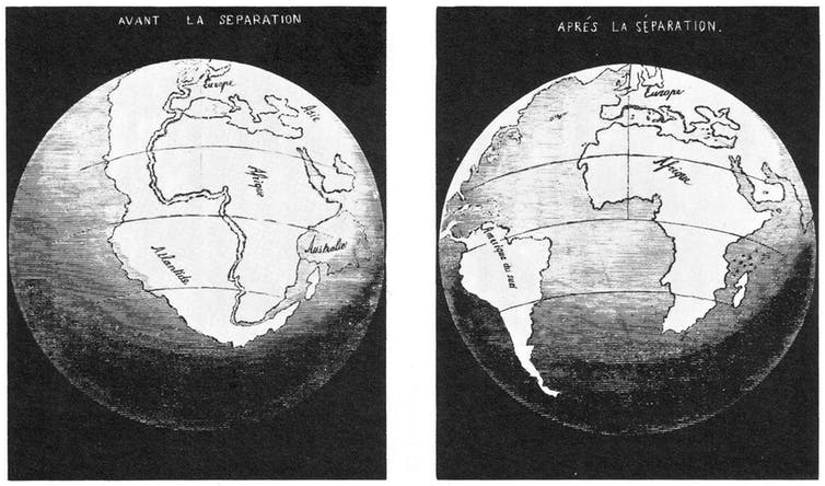 (Snider-Pellegrini/Wikimedia)
 (Snider-Pellegrini/Wikimedia)
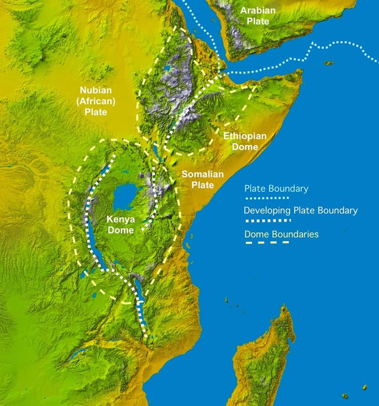 (James Wood/Alex Guth, NASA)
